The island rose without warning. On a quiet Atlantic evening, the sea west of Ireland looked unchanged until a dark form surfaced where open water should have been. A solid outline took shape. Hills emerged. Smoke appeared to lift into the air. Several people watched as the impossible scene lingered briefly, then slipped back into fog. Moments like this, repeated across generations, kept alive belief in Hy-Brasil, an island said to appear only to disappear again.
Hy-Brasil never settled into certainty. Instead, it hovered for centuries between land and illusion.
A Land That Lived In Mist
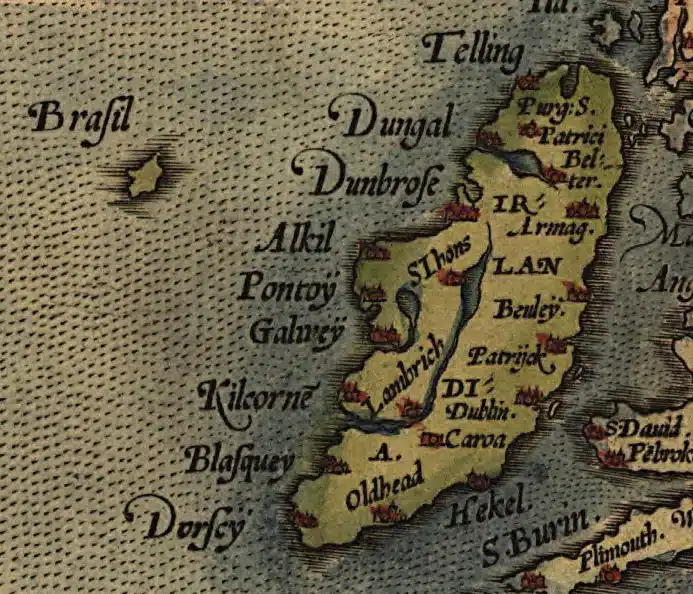
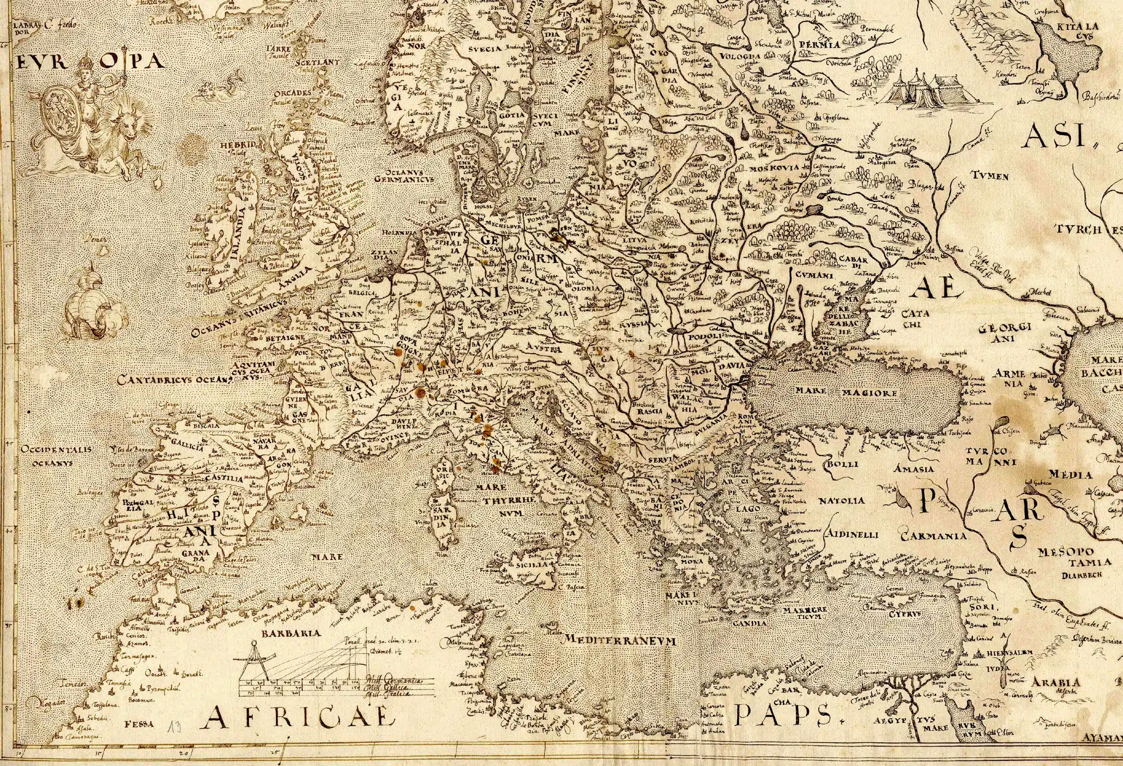
Hy-Brasil, also called Brasil, Hy-Breasil, or O’Brasil, existed in Irish folklore long before it appeared on parchment. Oral tradition described a hidden island cloaked by fog, visible once every seven years and unreachable even when sighted. The stories placed it somewhere west of Ireland, close enough to be seen from shore yet far enough to remain untouched.
By the early fourteenth century, mapmakers began giving the legend physical form. In 1325, Majorcan cartographer Angelino Dulcert included an island named Bracile in the Atlantic. Other charts followed. By the fifteenth century, Venetian maps labelled Insula de Brasil near Ireland’s western edge. The island often appeared as a near-perfect circle, sometimes divided by a straight channel, a shape that repeated with remarkable consistency.
Despite repeated failures to confirm its existence, Hy-Brasil stayed inked on maps.
When Sightings Became Stories
Not everyone accepted Hy-Brasil as fiction. Over time, reports emerged from people who believed they had reached it. In April 1668, an Irishman named Murrough O’Ley claimed he had been taken to O’Brasil after an unexplained encounter. He returned home unharmed and insisted he possessed healing abilities despite no medical training.
On 2 March 1674, Captain John Nisbet reported that his ship emerged from heavy fog beside an unfamiliar shore. Crew members described black rabbits, a solitary figure living in a stone structure, and gifts of gold and silver. Later research suggested parts of the tale were literary invention, yet the account spread widely and reinforced belief.
By the nineteenth century, sightings continued. In 1872, Irish antiquarian T. J. Westropp recorded watching an island appear suddenly at sea during sunset. He described wooded slopes, towers, and smoke rising from the land. His account came from a trained observer and included several witnesses.
In July 1878, fishermen in Ballycotton, County Cork reported seeing an island where they had sailed the day before. The conditions were clear. The land appeared rugged and solid. Then it vanished.
The Island That Maps Could Not Let Go
Hy-Brasil’s survival owed much to cartography. From the 1300s through the 1800s, European maps placed the island in shifting positions. Some charts showed it near Galway Bay. Others placed it farther south-west or duplicated it entirely. Nautical charts repeated the island even as expeditions failed.
By the eighteenth century, doubt crept in. Some maps labelled it imaginary. Others reduced it to Brasil Rock. In 1873, British Admiralty charts removed Hy-Brasil altogether. The phantom island finally disappeared from official geography.
Why The Island Looked Real
Later writers offered explanations that did not require land. Shallow underwater features such as Porcupine Bank or Rockall may have played a role. More persuasive was the behaviour of light itself. Irish antiquarian records describe optical effects now associated with mirages. Light bending over cold water can lift distant objects above the horizon, stretch their shapes, or create convincing images of land. Sailors called the effect looming.
Similar illusions produced reports of airborne ships and distant cities along Ireland’s western coast. What looked supernatural often traced back to reflection and refraction.
An Island That Refused To Sink
Even after maps erased Hy-Brasil, stories kept it alive. Irish poets wrote of it as a blessed land beyond sorrow. Folklore linked it to saints, including Brendan the Navigator, whose legendary voyage blurred faith and exploration. Manuscripts told of healers taught secret knowledge on the enchanted island before returning to Ireland.
Modern culture followed the same path. Films and novels reused Hy-Brasil as a hidden realm or threshold between worlds. The island changed shape but never vanished.
Hy-Brasil remains suspended between observation and imagination. It appeared often enough to convince sailors, scholars, and mapmakers. It disappeared consistently enough to resist proof. Each sighting added detail. Each failure deepened uncertainty.
The Atlantic still produces fog. Light still bends. On certain evenings, the horizon stretches farther than expected. Somewhere between the limits of sight and certainty, Hy-Brasil waits.
Photo Credit: Wikipedia